
Atlantic Tropical Activity Awakening as Hurricane Season 2022 heads towards its peak month of September

MORE 29th Prime Minister New Weather Warning The Latest From Sxmgov
It has been a surprisingly slow start of tropical cyclone activity in the Atlantic Basin since the beginning of Hurricane Season 2022. Compared to the Eastern Pacific activity, it’s been much quieter in the Atlantic Ocean.
There have only been three tropical cyclones so far, with the ACE – the Accumulated Cyclone Energy extremely low. But the peak of the Atlantic Hurricane Season is approaching fast. The Atlantic Ocean waters are very hot and therefore anomalously warm compared to normal, meaning the activity could ramp up very soon. The next potential tropical storm – Danielle – could be named this week.
The Atlantic 2022 hurricane season also had no named storms in the month of August so far. This is only the third time since 1960 that this happens, the other two years were 1961 and 1997. Still, a slow start does mean nothing about how the coming peak months of September and October will be. The overall conditions are very favorable for the upcoming peak season period ahead.
Currently, there are a couple of tropical waves moving west across the west-central Atlantic, where at least one of them could be the next named storm. That would be Danielle. This tropical wave has the highest potential to become better organized in the central Atlantic right now.
As global weather is a very complex system of chaos theory, the weather dynamics and patterns are also very different around the world. And the tropical dynamics are one of the more complex things, having a lot of factors involving that all combined together. The perfect combination of these then leads to dangerous tropical weather threats for the land and property. Latest St Maarten Hurricane 2022 New Updates And The News
The Atlantic Hurricane Season 2022 has started with a very low, almost record-low activity, producing only three named storms so far. Now, as we are closing in on the peak of the season, a more significant increase in activity is forecast to develop soon.
During an average tropical year, the Atlantic hurricane season produces up to 14 named tropical storms. On average, 7 of those normally become hurricanes, with around 3 of them reaching the major strength (hurricane of a Category 3 or greater). https://www.stmaarten.news

A typical Atlantic hurricane season activity has two peaks. The first period of increased activity occurs in the early through mid-September while the second boost in the activity normally happens through mid-October.
And https://www.sxmgovernment.com
Statistically, the general increase in activity across the tropical Atlantic normally begins in trough early/mid-August. This can tell us how under-average the ongoing low activity actually is. As also the very first hurricane typically develops in mid-August, while we had seen none formed yet in 2022. While last year we had the first hurricane forming almost 45 days earlier than normal.
As we are now heading into the final days of August, the extremely warm Atlantic Ocean sea waters are coinciding with the western edge of a large and deep MJO wave, moving east across the eastern Central Atlantic. And at the same time, tropical waves are ejecting from western Africa, being pushed towards the central Atlantic. Developing conditions for an increase in tropical activity. https://www.stmaartennews.org
The animation below is showing these waves and the corresponding cyclonic activity in the western Atlantic over the next 10 days. It is very likely that at least the one approaching the Caribbean from the central Atlantic will soon strengthen and become the next tropical storm Danielle. The other systems are in less favorable conditions and have only minor chances to see a significant increase in their development.
Tropical activity awakening as Atlantic Hurricane Season heads towards its peak month of September
Several tropical waves moving across Central towards the Western Atlantic – SWE /MK
Note, that hurricane development is a very specific formation in the tropical region. it is strongly sensitive to atmospheric conditions that are present at a given time. The above-mentioned MJO wave has a strong influence on the state of the atmosphere, thus allowing tropical storms or hurricanes to develop.
These systems normally require a very warm sea temperature (26 °C or above), including very high moisture present, and low vertical wind shear through the atmosphere. Where the tropical wave helps to develop a surface low-pressure system.
When these ingredients come together, a tropical cyclone could quickly become a hurricane or even a violent, major hurricane of a greater than Category 3 strength. This happens when all the required conditions are near perfect. As we are nearing the peak Atlantic hurricane season of 2022, the coming weeks will have a strong influence on these factors in the following weeks. The activity is forecast to significantly increase soon.
Unlike the mid-latitudes, the tropical region has no warm or cold fronts. The weather activity is in general a combination of showers and thunderstorms with a larger scale pressure and wind variability. Most of the tropical variability is driven by invisible wave-like features that we find in the atmosphere around the world.
The two most important waves are the MJO wave and the Kelvin waves. These two are the second and the third most needed ingredients after the warmth of the oceanic waters.
ATLANTIC BASIN IS VERY WARM, EVEN EXTREMELY WARMER OVER THE CARIBBEAN AND THE GULF
The Atlantic Ocean sea surface temperatures (SST) are normally very warm through the summer months, and so are its temperatures in 2022. But the recent sea surface temperature anomaly reveals that basically the whole Atlantic Basin, especially the western parts, has anomalously warmed up. These are including the Caribbean, and the Gulf of Mexico, having the surface waters extremely warm. While most of the Atlantic Ocean is warmer than normal as well.

The Atlantic Basin sea waters are the warmest in the western Caribbean region and the Gulf of Mexico. While the sea surface temperatures are from around 28 to 29 °C in the central tropical Atlantic, they are much warmer farther west. Up to around 30 °C in the northwestern Caribbean and even warmer in most of the Gulf of Mexico.
Water surface temperatures of 31 °C or even a warmer are observed over the easter Gulf of Mexico and around Florida. This is a very significant signal for the upcoming tropical storms that would track into this part of the Atlantic tropical region. The explosive development of tropical storms is often happening when they encounter such warm and moist fuel at the sea surface.
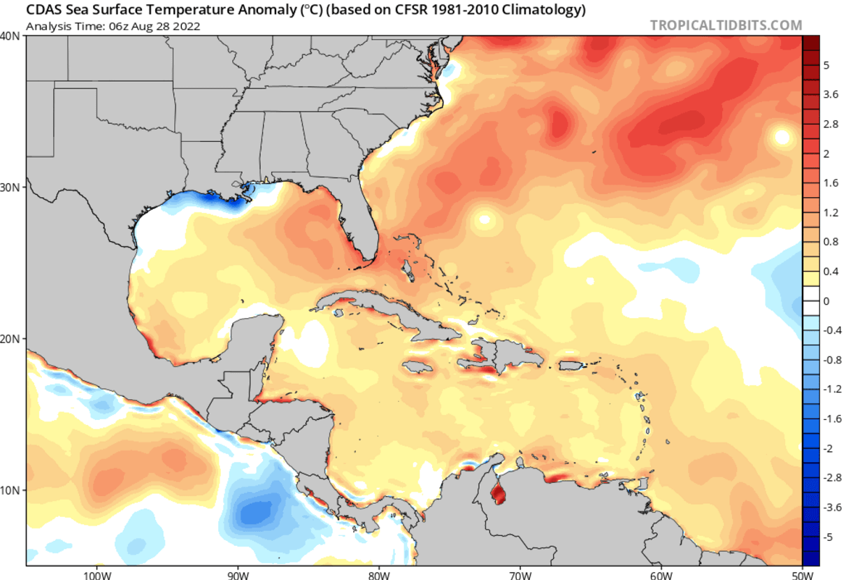
These sea waters are, thanks to the very calm weather across the tropical Atlantic in the recent weeks, anomalously warmed also across the so-called MDR region (Main Development Region) between Africa and the Caribbean Sea.
Once the tropical waves begin ejecting off the west coast of Africa, such temperature anomalies hint at the enhanced potential for significant tropical cyclone development. Convective storms are easily fueling themselves from the very warm tropical Atlantic ocean waters. According to the forecasts for the upcoming weeks, those will remain in place or even improve right through the peak of the Atlantic hurricane season in 2022.

Note that the current strongly anomalous SSTs are quite typical when the very active Atlantic hurricane season follows around the peak.
MJO WAVE – ATLANTIC HURRICANE SEASON BOOSTER
Recently, we have been tracking a pretty significant MJO wave over Africa that is now gradually moving east. Its western part is still over the eastern and central Atlantic, which initiated tropical activity through late August and should have an effect into early September.
The MJO wave is known as the Madden-Julian Oscillation or short MJO. It is a very important factor for tropical activity and cyclone formation around the world. The MJO is the largest and most dominant source of short-term tropical variability. This eastward-moving wave of convective showers and thunderstorms typically circles the entire planet in about 30 to 60 days.

The chart below, provided by Michael J. Ventrice, represents the MJO wave with filtered VP200 anomalies for the current week’s state and the forecast for a week ahead. The blue colors on the chart (cold) mean more favorable conditions for tropical cyclone development. While the red colors (warm) are showing where there is a less favorable state for tropical cyclogenesis present.
As we can quickly notice from the attached chart, there are favorable conditions over the Eastern Atlantic, improving over the Indian Ocean. While less favorable conditions are across the eastern Pacific Ocean and towards the western Atlantic Basin later on. This can directly tell us that conditions on both sides of central America are less supportive of tropical development this week, but those are significantly better towards the central and eastern Atlantic.
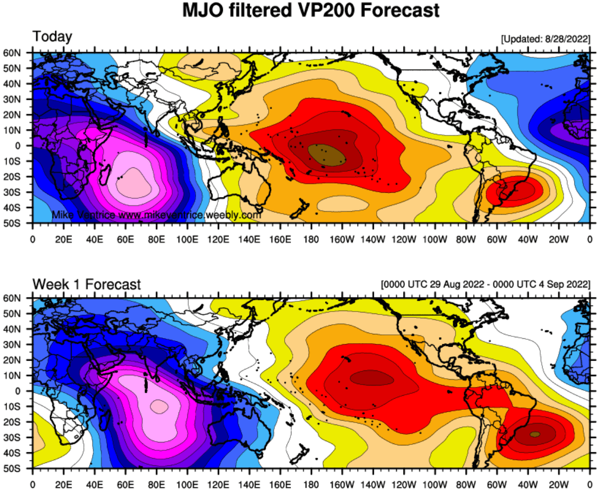
Note: On the posted chart above, the VP200 indicates a Velocity Potential (VP). This is an indicator of the large-scale divergent flow in the upper levels of the atmosphere over the tropical region. Where the blueish colors are present, the negative VP anomalies are found, meaning we have a divergent outflow from enhanced convective regions. Often, if combined with low shear and high sea surface temperatures, this leads to tropical cyclogenesis.
The reddish colors, indeed represent the opposite in this case, a converging flow aloft and suppressed convective activity in the region underneath. A deep MJO wave also develops a lower wind shear environment which is also another important factor that helps to trigger tropical storm development.
Besides the MJO wave, there are also other waves that are directly related to the large-scale wave as MJO is. Those are the atmospheric Kelvin waves and have a smaller size than the MJO. These waves are tropical rainfall systems accompanied by characterized westerly and easterly wind patterns.
ATLANTIC HURRICANE SEASON 2022 SO FAR
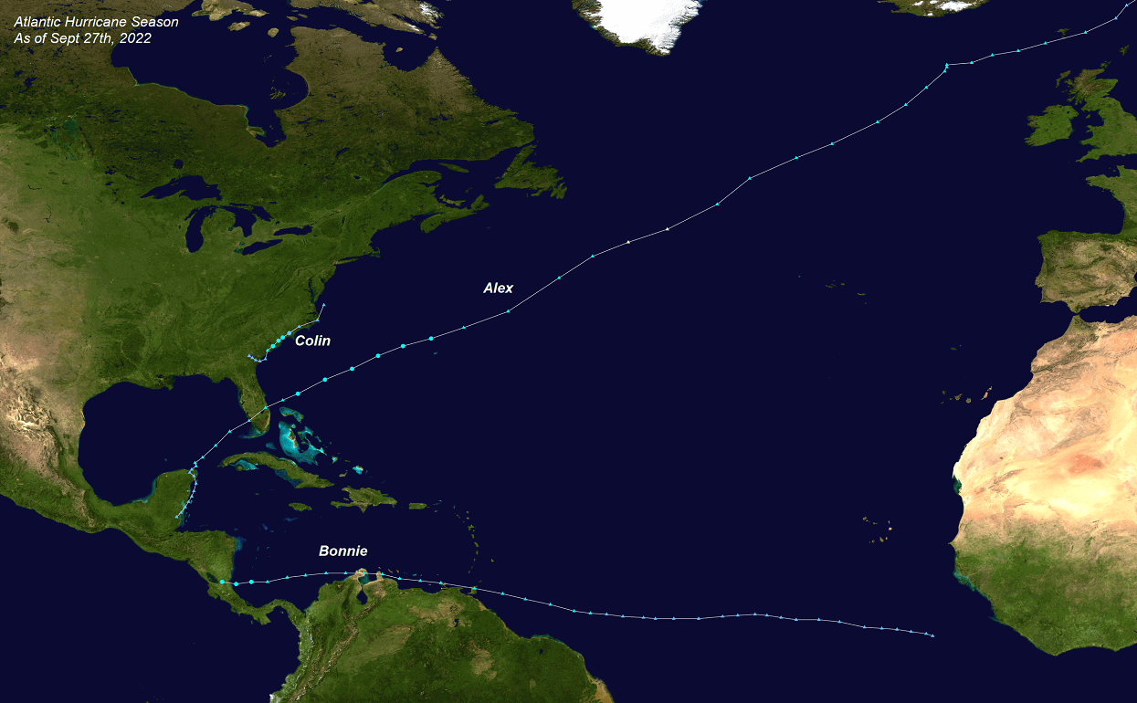
The Atlantic hurricane season 2022 began with a slow start. The first storm Alex formed just a few days after the official start on June 1st. Alex had peak winds of 70 mph and only lasted for two days.
The next tropical storm Bonnie formed almost a month later, on July 1st. Same as Alex, Bonnie was only 2 days active in the Atlantic Basin. However, this system has crossed central America and continued into the Eastern Pacific Basin as hurricane Bonnie for another week.

On July 2nd, there was also an area of tropical activity along the southeast Atlantic Coast, and tropical storm Colin formed. It brought a lot of rain to South Carolina which lead to flooding. Colin lasted for 2 days only.
Since then, there was no tropical activity or named storms until now. A nearly 7 weeks break in the Atlantic Basin. This is, compared to the activity of the last two years, a very slow start. There have been no hurricane formations in the Atlantic season 2022 yet. So also the energy these systems produced is at a very low level for now.
When it comes to monitoring the activity in tropical regions around the world, we use a so-called ACE index to express the energy that was used during the tropical cyclone’s lifetime. This is how we can easily compare every tropical storm or hurricane with the other in a given year. The ACE, known as the Accumulated Cyclone Energy index, was invented.
But what is the ACE index and how can we use it in forecasting and analyzing the Atlantic hurricane season?
The ACCUMULATED CYCLONE ENERGY (ACE index)
So, the ACE index is an abbreviation for Accumulated Cyclone Energy, short: ACE. This index is used for all tropical regions around the world. But as our focus here is on the Atlantic Hurricane Season, let’s take a look at how the NOAA forecasters have set 4 categories to classify storms by the ACE index:
- Extremely active – ACE index above 152.5
- Above-average – ACE index above 111
- Near-average – ACE index between 66 and 111
- Below-normal – ACE index below 66
Just a brief look at these numbers might not tell us a lot yet, but let’s see a bit deeper what it actually means. For example, the whole record-breaking Atlantic hurricane season in 2020 has had an ACE of 184.5. Looking at the thresholds above, it was quite well above the ‘extremely active’ category. That hurricane season was also among the 10 most active in the Atlantic based on the ACE index.

The chart above indicates the Atlantic hurricane season statistics for the recent 70+ years. We can see some years had an extreme amount of ACE, well above 200 with a large number of tropical systems, lasting for many days – this generates the most ACE.
So far, the Atlantic hurricane season 2022 has an extremely low value, as we have learned how poor activity so far has been. 2022 has only generated 2.9 of ACE which is about 10% of an average ACE through August 27th. This is indeed low for now, thanks to only three named storms and none of there ever reaching hurricane strength. Also, those were lasting just a few days altogether.
A very slow start is obvious. But to repeat, these numbers mean nothing about how the peak Atlantic hurricane season could be, as the numbers could significantly increase in the coming weeks with the tropical activity ramping up through September. Especially as we are expecting the major MJO wave to emerge later next month.
TROPICAL ACTIVITY RETURNS FROM LATE AUGUST INTO EARLY SEPTEMBER
There are now several waves emerging into the eastern and central Atlantic and at least one of them could be soon upgraded into a tropical depression or even a tropical storm in the coming days. They have both developed in the Main Development Region, soon after the strong thunderstorm activity ejected off the coast of western Africa.
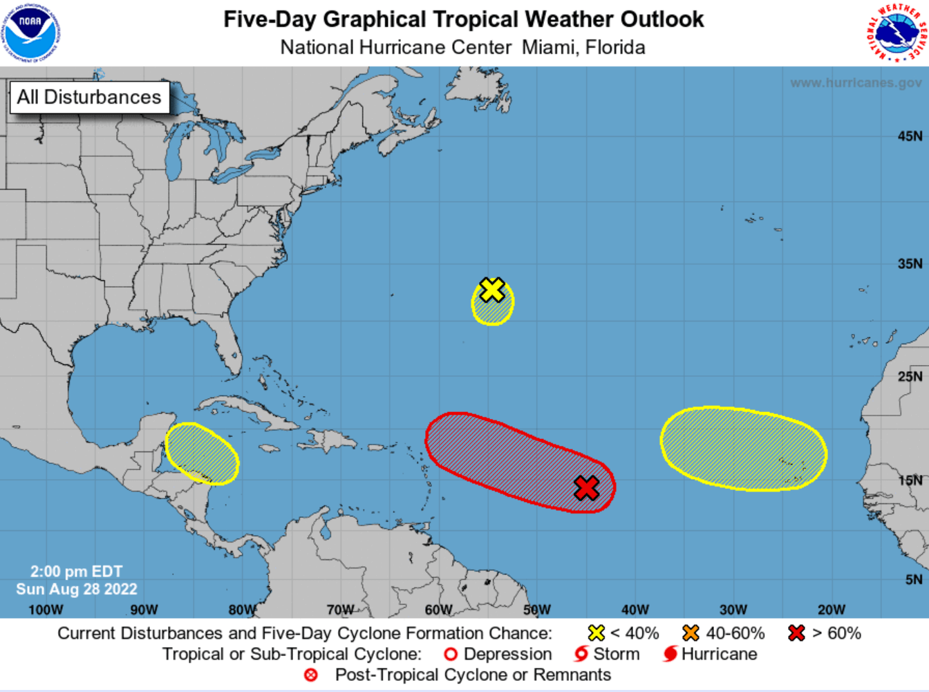
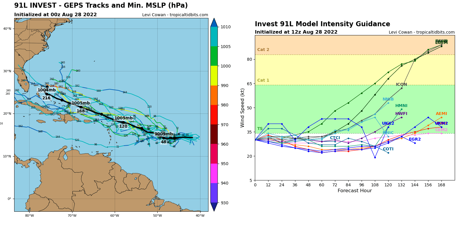
The first wave has a broad and elongated area of low pressure located over the central tropical Atlantic Ocean. The environmental conditions are expected to be generally conducive for gradual development in the following days, and a tropical depression is likely to form this week.
While the depression will be moving towards the west and then west-northwest at around 10 mph. Approaching the very warm waters east of the Leeward Islands in the first days of September.
The National Hurricane Center (NHC) is giving this system a 30 % chance to become a depression in 2 days but also a 70 % chance to become a more organized depression or even a tropical storm Danielle in the next 5 days.
There is another tropical wave in the northwestern Caribbean Sea where a trough of low pressure could develop during the middle part of this week. Environmental conditions could support some slow development of the system thereafter while it moves generally west-northwestward over the northwestern Caribbean Sea and toward the Yucatan Peninsula of Mexico.
The system has about a 20 % chance to become a depression in 5 days.
The third tropical wave to watch is located in the Eastern Tropical Atlantic. This wave is forecast to move off the west coast of Africa through Monday night with some gradual development of the system possible after that time while it moves generally westward across the far eastern tropical Atlantic. It has about a 20 % chance to become a depression in 5 days.
*******
With the peak of the Atlantic Hurricane Season approaching fast, residents of the coastal areas should always be hurricane aware, no matter the forecast.
Our team will be closely monitoring any further development of the Atlantic Hurricane Season and will keep you up to date with every potential land impact of tropical cyclones that will develop. Stay tuned.

